|
Recent Projects We Have Accomplished
Listed below are a few representative examples of work Wolf Engineering has successfully completed over the past two years.
|
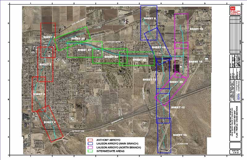
Anthony, NM - Hydrology Study & Drainage Management Plan
This project involved detailed engineering analysis that determined existing flood threats to the Town of Anthony, New Mexico resulting mainly from severe monsoonal rainfall events. Analyses completed quantified the amount and timing of potential flood flows (hydrograph determination), determined potential flood depths and flow velocities resulting from these flows, and provided recommendations to address existing flood problems and to minimize future flooding. Detailed computer simulations using HEC-HMS and HEC-RAS were completed as part of the project. The project was successfully completed in May of 2012 with the submittal of the Final Engineering Study Report.
Read the Executive Summary
|
|
Rio Grande Restoration Work:
Wolf Engineering has successfully completed detailed planning and engineering studies for the Rio Grande from the Angostura Diversion Dam north of Albuquerque to San Marcial, NM near the headwaters of Elephant Butte Reservoir. We've provided; hydrologic, hydraulic and geomorphologic expertise, general oversight, and assistance with the selection and assignment of specific restoration projects and locations in each project reach. We were then responsible for engineering on all selected restoration sites. We produced plans, profiles, and details for each selected site along with preliminary construction specifications and cost estimates for the proposed sites. We used advanced CADD and GIS software to accomplish all layouts and drawings.
Most recently, we provided our expertise in the development of the Albuquerque Reach Habitat Analysis and Recommendations report to assist the U.S. Army Corps of Engineers and the Middle Rio Grande Endangered Species Collaborative Program. This study was conducted to help meet requirements specified in the U.S. Fish and Wildlife Service (USFWS) 2003 Biological and Conference Opinions on the Effects of Actions Associated with the Programmatic Biological Assessment of Reclamation's Water and River Maintenance Operations, Army Corps of Engineers' Flood Control Operation, and Related Non-Federal Actions on the Middle Rio Grande, New Mexico. The purpose of the study was to evaluate existing conditions, analyze available habitat, and develop recommendations for restoring habitat for the Rio Grande silvery minnow and the southwestern willow flycatcher within the Albuquerque Reach of the Middle Rio Grande (from Angustora Diversion to Isleta Diversion).
We assisted with; an analysis of existing data and information to identify data gaps, conducted an analysis of available habitat, and developed restoration alternatives to increase or enhance existing habitat. We then conducted an analysis of habitat suitability to assess hydrologic, hydraulic, and geomorphic conditions associated with design flows to assess future habitat conditions.
We completed the hydrologic analysis and modeling (HEC-RAS, FLO-2D) of the existing hydraulic conditions; assisted with the development of the restoration alternatives; completed preliminary engineering for the alternatives; modeled the future geomorphic and hydraulic conditions; and provided preliminary construction cost estimates.
|
|
Eakes Road / Griegos Lateral Crossing:
The Eakes Road Bridge replacement project in the North Valley of Albuquerque, NM was designed and constructed in 2012. The project consisted of replacing an under sized culvert crossing (with severely eroding abutments) on the Griegos Lateral with a bridge founded on cast in place concrete piles. Because the crossing provides the only ingress /egress for 13 homeowners, it had to be designed for HS20 loading to accommodate emergency vehicle access. With minimal right-of-way available, numerous utilities encroaching on the available footprint, access requirements for the Middle Rio Grande Conservancy District's maintenance equipment, and a home owners association very particular about the appearance of the final structure, the challenges were many. With close coordination and frequent communication with all affected parties, the project was successfully designed and constructed in a short timeframe. We partnered with Albuquerque based Quiroga-Pfeiffer Engineering on the design work.
|
|
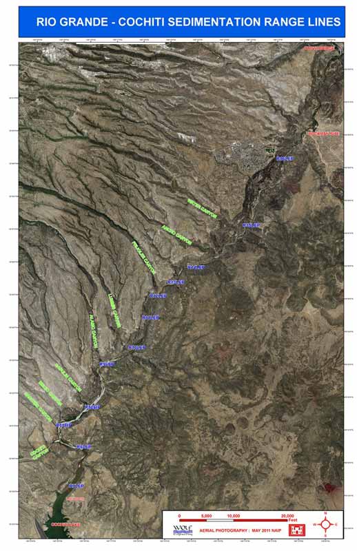
Cochiti Lake & Rio Grande - Hydrographic Data Collection
In the spring of 2012 and 2013 under contract with the Albuquerque Corps of Engineers Office, hydrographic surveys were conducted by Wolf Engineering to collect data to monitor the change in channel conditions for the Rio Grande upstream of Cochiti Reservoir prior to the spring run-off seasons. Cross section survey data was collected and post-processed for eleven Range Lines located between White Rock Canyon and the reservoir. Additionally, bathymetric data was collected for Range Line 7 (within the reservoir) and at the river/lake interface (sediment delta).
The riverine surveys were performed during three day raft trips in which Wolf used its HDC boat along with RTK-GPS, a total station, engineer's level and tag line, and other supporting equipment to acquire all of the required data. In addition to the cross section topography; bed form, substrate type, habitat classification, and complete photographic documentation were recorded at each cross section. End point coordinates obtained using the RTK-GPS were used to control the hydrographic surveys. All data was reported in US survey feet units and elevations were provided in both NGVD 29, to match historical surveys, and NAVD88.
At RL-7 and the sediment delta, the team used survey grade (Trimble R-8) RTK GPS seamlessly integrated with a Hydrolite depth sounder mounted on our small motorized HDC boat to collect over a thousand points each year to accurately define the required bathymetric data in these areas. Results of this work were very well received by the Corps, as it illustrated the vast amounts of sediment / debris that recently deposited due to run-off on the burn scar from the 2011 Los Conchas Fire.
Deliverables for the contracts included complete hydrographic data collection reports containing all the post processed survey data tabulated station-elevation data with bed form and habitat, GIS files of the data, and plotted plan and profiles (11"x17") for each of the Range Lines. Recent aerial photography was used as a backdrop on all the plan plots. Doug Wolf was hydrographic data collection crew chief, and project manager for all the work.
Read the 2013 Executive Summary
|
|
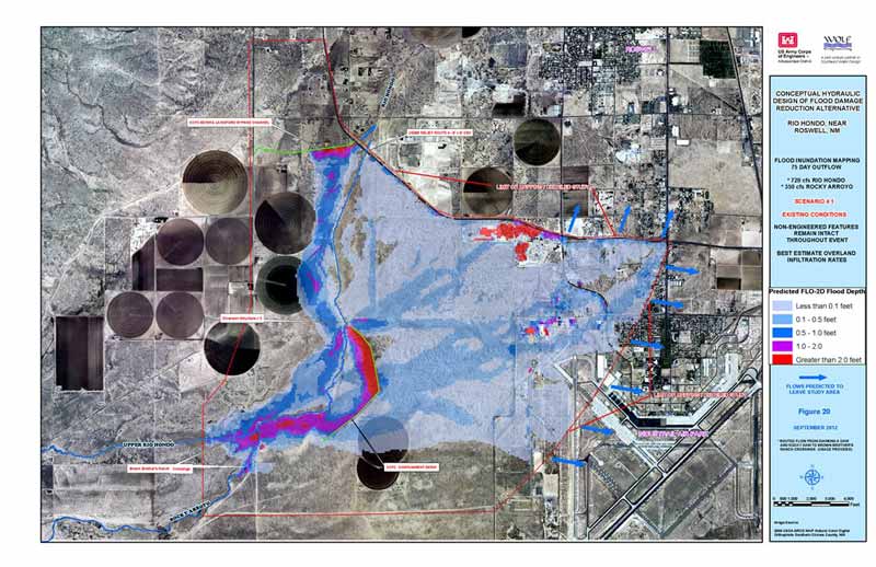
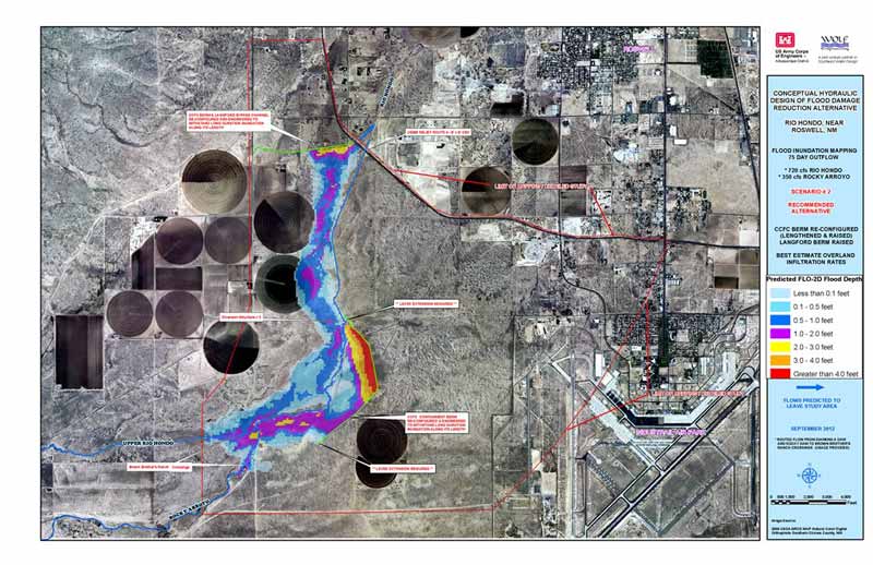
Rio Hondo - Flood Hazard Analysis & Proposed Mitigation Plan
Wolf Engineering used the two dimensional flood routing software, FLO-2D, to simulate various operational releases from the Two Rivers Dam as they progress along a five mile reach of the Rio Hondo immediately west of Roswell, NM. In-channel and overbank flows are integrated within the model and detailed results depicting flooding limits, flood durations and flow velocities were produced. We made extensive use of detailed 2009 LiDAR mapping data and Digital orthophotography in the development of the FLO-2D model as well as in the production of the highly detailed ArcGIS maps showing study results. We produced and delivered a comprehensive project report to the Albuquerque District Corps of Engineers. A follow-up Contract from the Albuquerque District was issued to Wolf Engineering in 2012 to develop a conceptual hydraulic design for a levee to contain the floodplain identified in the original study. We completed additional hydraulic modeling in support of this phase of the project and developed plan & profile, cross sections, and details using CADD and GIS for the proposed flood mitigating alternative.
Read the Executive Summary
|
|
Buckman Direct Diversion Monitoring:
Wolf Engineering is providing hydrographic surveys to assist the Buckman Direct Diversion (BDD) meet the requirements specified by the National Pollutant Discharge Elimination System (NPDES) permit. The permit requires aquatic and morphologic evaluation downstream of the sediment outfall to monitor the accumulation of sediment deposits through the duration of the NPDES permit, which expires in 2013. The purpose of the hydrographic studies is to evaluate the impact of downstream sediment discharge during operation of the BDD project to the physical and biological characteristics of the Rio Grande.
To date, we have completed eight sets of hydrographic surveys for the seven range lines that were installed in the vicinity of the Direct Diversion Project on the Rio Grande. During the first set of surveys in March of 2011, we installed rebar, cap, and steel T-posts for each endpoint for the seven cross sections. And used a survey grade RTK GPS to record XYZ coordinates for each of these endpoints. Subsequent surveys have all been successfully completed using an engineer's level and tag-line under varying weather (ice flowing in river) and flow conditions (450 cfs to 1300 cfs) on the river. Complete photographic documention, bed form assessment, substrate type, water surface elevation measurements, and overbank habitat classification have been recorded and compiled into a thorough Hydrographic Data Collection Report for each set of surveys.
|
|
Flood & Erosion Hazard Analyses - Various Tribal Lands throughout New Mexico:
Since 2009 Wolf Engineering has served continuously as a consultant to the Indian Health Service's, Albuquerque Project Office supporting water and wastewater infrastructure planning and design. Our primary role has been the development of detailed hydrologic, hydraulic, and geomorphologic reports for various waterways that traverse through the Indian Pueblos within the State of New Mexico. Three of our recent projects include;
Zuni Pueblo: The study includes the determination of flood hazards along the Zuni River from rare storm events that could occur over the Zuni River watershed. Detailed results (water surface elevations, flood profiles, and floodplains) were prepared for a six mile reach of the river in the vicinity of Zuni Pueblo. We modeled over 900 square miles of drainage area using HEC-HMS, collected 18 riverine cross sections (ranging in length from a few hundred feet to nearly a mile) using survey grade RTK-GPS, and used HEC-RAS to develop water surface profiles for various hypothetical storm scenarios in support of the project. All of the field data and digital results from the study were provided in the IHS's preferred coordinate system (modified NM State Plane NAD 83 grid coordinates with NAVD88 elevations). All work on the study was documented in a detailed Flood Hazard Analysis Report completed in September of 2012.
Zia Pueblo: We successfully completed a hydrologic and hydraulic analysis for a three mile reach of the Jemez River through Zia Pueblo, New Mexico. This was a collaborative project between the Office of Environmental Health and Engineering of the Indian Health Service (IHS) and the Zia Pueblo. The goal of the study and analysis is to quantify the potential for, and predict the magnitude of, flooding along the River. The hydraulics (floodplains) were computed using the U.S. Army Corps of Engineers River Analysis System (HECRAS). We collected 25 riverine cross sections using survey grade RTK-GPS in support of the HEC-RAS modeling. Cross section photographs and bed form were also documented at each cross section. We produced a detailed project report documenting all assumptions and displaying study results.
Laguna Pueblo: The work included flood frequency analysis for nearby stream gages, rainfall-runoff model development (HEC-HMS), geomorphic data collection along the Rio San Jose (2 reaches totaling 4 river miles), and river hydraulic modeling using HEC-RAS. Detailed flood elevations and likelihood of stream erosion were determined for existing and proposed wastewater infrastructure located adjacent to the river. We collected 33 riverine cross sections using survey grade RTK-GPS in support of the HEC-RAS modeling and three bed material sediment samples in support of the geomorphic assessment of project reach # 2.
|
|
Rite Way Pallet - Storm Water Pollution Prevention Plan
In 2012, Wolf Engineering completed a written Stormwater Pollution Prevention Plan (SWPPP) for the wooden pallet manufacturing company located in the South Valley of Albuquerque, NM. This work was done in support of obtaining a storm water discharge permit to be in compliance with the U.S. Environmental Protection Agency (USEPA) administration of the Clean Water Act. The facility is seeking a Multi-Sector General Permit (MSGP) for Stormwater Discharges associated with Industrial Sources Sector A: Timber Products Facilities.
Requirements necessary for coverage under the MSGP are; a written storm water pollution prevention plan (SWPPP), implementation of control measures, and submittal of a request for permit coverage - referred to as a Notice of Intent (NOI). The SWPPP is a written assessment of potential sources of pollutants in storm water runoff and control measures that will be implemented at the facility to minimize the discharge of these pollutants in runoff from the site.
Among other information, the SWPPP included a control measure (BMP) near the main driveway entrance to collect and temporarily store storm water originating from the site. A general sketch plan of the BMP is included in the SWPPP.
|
|
|
|
|
|
|
| © Wolf Engineering llc |
Designed by idu1.com |
|